Turn an address into a decision-ready climate risk profile.
Property-level scores across six perils, built with NOAA, FEMA, USGS, ERA5 reanalysis, and other public or authoritative risk context. Built for underwriting, real estate, and ag finance teams who need exposure context they can explain.
6
Perils scored per propertyNamed
Source-labeled risk contextFast
Address to profile workflowU.S.
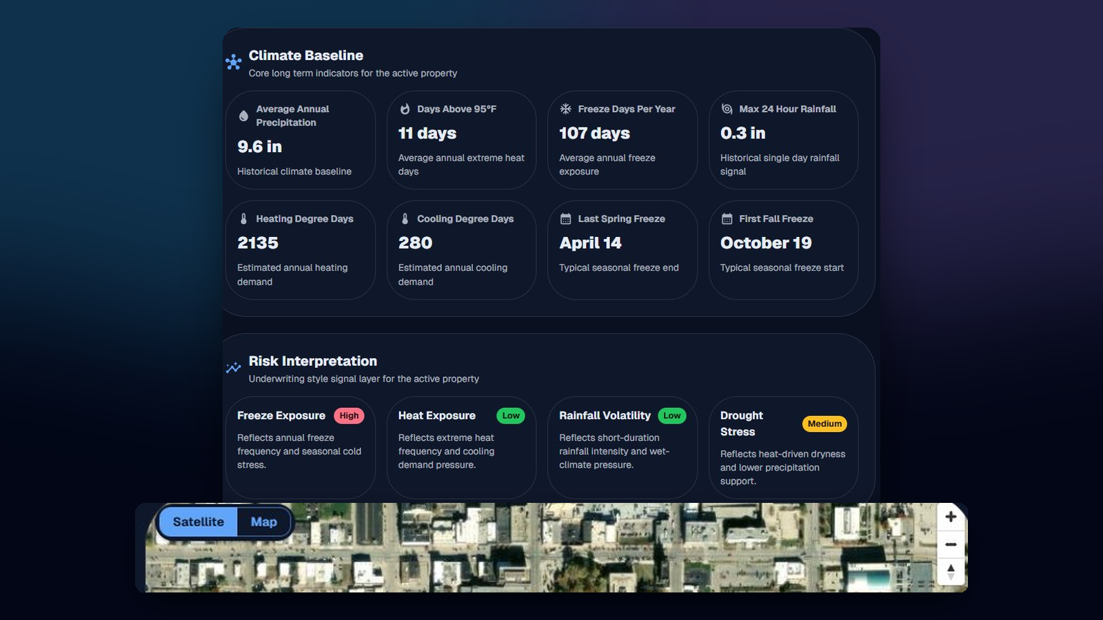
Property and portfolio coverageWhat a property profile looks like.
Illustrative profiles below. Live profiles combine available public hazard, weather, flood, gauge, wildfire, and climate reanalysis context at the property coordinates.
Boulder, CO
22
Low risk
Tampa, FL
71
High risk
Lubbock, TX
48
Moderate risk
Single properties or multi-location schedules
Six named perils with source context on every profile
Built for business users, not consumer home search
Built for teams making financial and operational decisions on real assets.
This platform is designed for professional property evaluation where weather, climate, and location exposure matter to the decision.
Commercial property underwriters
Evaluate property-level exposure to flood, hurricane, hail, wildfire, heat, and freeze before quoting, renewing, or reviewing risk.
Real estate and advisory teams
Screen assets, portfolios, and locations for weather-sensitive exposure during acquisition review, brokerage support, or client advisory work.
Ag finance and trading teams
Review temperature and precipitation context, seasonal patterns, and climate exposure for operations, lending, and weather-sensitive positions.
Weather-exposed operators
Support energy, logistics, and other weather-sensitive operations with location-level climate context and decision support.
A decision-ready climate profile for every property or schedule.
Outcomes you can act on: clearer screening, stronger underwriting context, and faster review of weather-exposed assets.
Six peril scores per property
Flood, hurricane, hail, wildfire, heat, and freeze — each scored 0 to 100 with the inputs that moved the score visible alongside.
Single address or full SOV
Run one location or upload a schedule. Composite score, per-peril breakdown, and source context are consistent across both.
Flexible location input
Start from an address, a map location, or a defined property shape depending on how your team works.
Layered climate context
Historical weather, peril frequency, and climate exposure brought into one view that supports faster business decisions.
Decision support
Move beyond raw weather data with business-friendly interpretation designed for review and action.
Property and flood context
See location context alongside climate signals so property-level exposure is easier to understand.
Scores are designed to show the sources behind the signal.
Each peril score is built to expose the public, authoritative, or reanalysis context behind the result so teams can review, explain, and challenge the output.
FEMA NFHL
Flood zones and base flood elevationNOAA HURDAT2
Historical hurricane tracks and intensityNOAA SPC
Severe storm and hail event databaseUSFS WHP
Wildfire hazard potential and fuel modelsERA5 reanalysis
Hourly temperature and precipitation historyNOAA NCEI
Climate normals and freeze and thaw historyUSGS
Stream gauges and elevation modelsNOAA NWS
Active alerts and watch and warning feedsThree steps from a location to a decision-ready profile.
Request access
Tell us about your organization and use case so we can keep access aligned to the right professional workflows.
Define the property or portfolio
Enter a property, location set, or structured schedule depending on the way your team evaluates exposure.
Review the profile
Get peril scores, source context, and exposure signals in a format built to support underwriting, advisory, and screening decisions.
Public weather tools, no login required.
Multi-model forecasts, temperature maps, flood views, heat index, and marine dashboards. Useful on their own, and a quick way to explore the platform experience.
Ready to evaluate weather exposure on your own properties?
Request access and tell us about your team. We will use that information to qualify fit and support the right underwriting, real estate, or operational workflow.